Weather Data, Part II: Thermal Activity
![]()
Signs of Thermal Activity, the Structure of Thermals, the Diurnal Thermal Cycle, and Reading the Sky
Signs of Thermal Activity
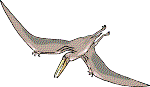
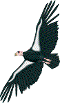
Signs of thermals include: (1) objects heavier than air moving upward without any apparent expenditure of energy, (2) frequent changes (i.e. over a time scale of seconds to minutes) in the direction and velocity of the wind, (3) dust devils, and (4) particular types of clouds (see below and see next page). Objects moving upward (or remaining suspended at the same level) include thistle down, leaves, soaring birds, soaring butterflies, and gliders. In each case, the energy lifting the object upward is the kinetic energy of the air. One of the easiest ways of locating soaring monarch butterflies is to rely on the presence of soaring birds, such as gulls, hawks, vultures, swallows, or swifts, to mark a thermal and examine the air in their immediate vicinity. If the season, wind, and temperature conditions are favorable and the butterflies are reasonably abundant, they apparently exploit most thermals, including those with birds. Locate the birds, and you locate the butterflies. A wind that changes direction and velocity frequently indicates that thermals are drifting through and past your site. Dust devils are organized cores of plume thermals. Clouds associated with thermals include low to mid level cumulus clouds, and cumulonimbus clouds. Thunderstorms, tornadoes and hurricanes are also associated with strong lift but are best studied from a great distance.
Structure of Thermals
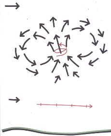 Thermals
are convection systems that range in diameter from a meter or less near the ground to a
thousand meters or more at several thousand meters above the ground. Thunderstorms are
giant thermal systems and often have more than one convection cell. Thermals exploited by
animals for soaring are considered to occur in two basic types; vortex rings and plumes.
The first diagram on the right illustrates a vortex ring thermal, the diagram on the left
shows a plume thermal. In each case, straight black arrows indicate wind direction, curved
black arrows shows the circulation of air, and red arrows indicate the flight path of a
butterfly. A series of crossbars on the red line indicate flapping flight, absence of
crossbars indicate gliding, or soaring flight. The diagrams illustrate four important
characteristics of thermals: (1) rising air (lift), in the core of the convection system
can be surrounded by a larger area of descending air (sink),
Thermals
are convection systems that range in diameter from a meter or less near the ground to a
thousand meters or more at several thousand meters above the ground. Thunderstorms are
giant thermal systems and often have more than one convection cell. Thermals exploited by
animals for soaring are considered to occur in two basic types; vortex rings and plumes.
The first diagram on the right illustrates a vortex ring thermal, the diagram on the left
shows a plume thermal. In each case, straight black arrows indicate wind direction, curved
black arrows shows the circulation of air, and red arrows indicate the flight path of a
butterfly. A series of crossbars on the red line indicate flapping flight, absence of
crossbars indicate gliding, or soaring flight. The diagrams illustrate four important
characteristics of thermals: (1) rising air (lift), in the core of the convection system
can be surrounded by a larger area of descending air (sink), 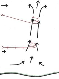 (2) the relative
narrowness of the core of rising air requires a soaring butterfly, to circle to remain
within the lift and avoid flying out of the thermal into air that is not rising, or even
air that is sinking, (3) as the butterfly nears the top of the thermal, the diverging air
flow tends to push the migrant out of the core and into descending air, and (4) thermals
drift downwind. The diagram on the right also shows that butterflies can fly under a
vortex ring without encountering lift or sink. The diagram on the left shows that plume
thermals lean downwind because wind velocity increases with altitude. Because to this
lean, glider pilots are taught to search for lift upwind of the clouds. Finally, the
diagram on the left shows a butterfly gliding down from a higher altitude encountered the
thermal and has begun to soar upward. If it links a series of upward soaring climbs with
straight glides, always finding another thermal before it reaches the ground, the
butterfly would be able to fly for hours without having to flap its wings.
(2) the relative
narrowness of the core of rising air requires a soaring butterfly, to circle to remain
within the lift and avoid flying out of the thermal into air that is not rising, or even
air that is sinking, (3) as the butterfly nears the top of the thermal, the diverging air
flow tends to push the migrant out of the core and into descending air, and (4) thermals
drift downwind. The diagram on the right also shows that butterflies can fly under a
vortex ring without encountering lift or sink. The diagram on the left shows that plume
thermals lean downwind because wind velocity increases with altitude. Because to this
lean, glider pilots are taught to search for lift upwind of the clouds. Finally, the
diagram on the left shows a butterfly gliding down from a higher altitude encountered the
thermal and has begun to soar upward. If it links a series of upward soaring climbs with
straight glides, always finding another thermal before it reaches the ground, the
butterfly would be able to fly for hours without having to flap its wings. 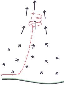 The vortex
ring and the plume model are both approximations of the actual shapes of thermals and
there is no hard line dividing the two. In a sense, all thermals are vortex rings. Even
though a a plume thermal appears to consist entirely of a rising column of air entirely
sustained by in rushing, warm, surface, air, there is more to the system. A plume thermal
is also surrounded by an large area of cooler air gently settling to replace the warm air
rushing upward. A plume thermal can be considered a vortex ring attached to the ground.
However, the turbulent, chaotic, convection systems do not necessarily follow the rules,
and often organize in surprising ways. Near the ground, thermals may lack definite
boundaries, blending with local convective circulation between adjacent hot and cool
regions (e.g.rock outcrops in fields, fields next to forests, etc.) or they
may be organized into clearly defined systems such as dust devils. Monarch butterflies are
often able to exploit thermals near the ground. The second diagram on the right indicates
how migrating monarch butterflies fly upward to enter a plume thermal from the bottom.
Butterflies initially proceeding by cruising flight within 3 meters of the ground will
abruptly begin to fly upward, beating their wings more frequently, as they gain altitude.
At an altitude of about 15 m, the butterflies begin to soar in circles and continue to
gain (or maintain) altitude as they drift downwind. My field data indicate that
butterflies engaging in this maneuver manage to soar away at least 95% of the time. It is
not know how the butterflies are able to recognize that they are at the base of a thermal.
The vortex
ring and the plume model are both approximations of the actual shapes of thermals and
there is no hard line dividing the two. In a sense, all thermals are vortex rings. Even
though a a plume thermal appears to consist entirely of a rising column of air entirely
sustained by in rushing, warm, surface, air, there is more to the system. A plume thermal
is also surrounded by an large area of cooler air gently settling to replace the warm air
rushing upward. A plume thermal can be considered a vortex ring attached to the ground.
However, the turbulent, chaotic, convection systems do not necessarily follow the rules,
and often organize in surprising ways. Near the ground, thermals may lack definite
boundaries, blending with local convective circulation between adjacent hot and cool
regions (e.g.rock outcrops in fields, fields next to forests, etc.) or they
may be organized into clearly defined systems such as dust devils. Monarch butterflies are
often able to exploit thermals near the ground. The second diagram on the right indicates
how migrating monarch butterflies fly upward to enter a plume thermal from the bottom.
Butterflies initially proceeding by cruising flight within 3 meters of the ground will
abruptly begin to fly upward, beating their wings more frequently, as they gain altitude.
At an altitude of about 15 m, the butterflies begin to soar in circles and continue to
gain (or maintain) altitude as they drift downwind. My field data indicate that
butterflies engaging in this maneuver manage to soar away at least 95% of the time. It is
not know how the butterflies are able to recognize that they are at the base of a thermal.
Diurnal Thermal Cycle
On a typical day under the influence of a high pressure system the morning begins
with a clear sky, the ground feels cool to the touch, and there is no wind. The nocturnal
inversion is in place with cooler, denser air at the surface. Air temperature increases
with altitude up to the top of the inversion layer (altitudes of 100 to 300 m are common),
then temperature decreases with altitude.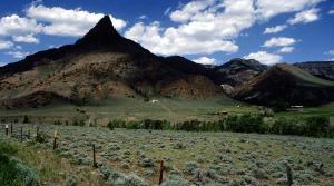 As the sun begins to heat the ground, and
the ground begins to heat layer of the air immediately above, the inversion starts to
become unstable. Around mid morning, Thermal Puffs (i.e.
small parcels) of warm, moist, air begin lifting off from the ground. The parcels of warm
air are quickly undercut by inflowing cooler air, become detached, and begin rising.
Rising puffs cool by expansion, but continue upward as long as they are still warmer than
the surrounding air. As long as the inversion remains intact, puffs of warm air cannot
rise very far before encountering a layer of air of similar temperature and coming to a
halt. As heating intensifies, some of the warmer puffs are able to push past the top layer
and into the cooler air above. Once clear of the inversion, the puffs are able to rise
much higher before encountering a layer of air of similar temperature. Small, wispy,
clouds form when the rising parcels of air are finally cooled to their dew points. Clouds
formed by rising puffs lack flat bottoms and are short lived. The small, poorly defined,
clouds to the right of the peak in the picture above left are probably thermal puffs.
Glider pilots watch for these clouds and consider their appearance an indication to get
ready to launch as full scale convection is about to begin.
As the sun begins to heat the ground, and
the ground begins to heat layer of the air immediately above, the inversion starts to
become unstable. Around mid morning, Thermal Puffs (i.e.
small parcels) of warm, moist, air begin lifting off from the ground. The parcels of warm
air are quickly undercut by inflowing cooler air, become detached, and begin rising.
Rising puffs cool by expansion, but continue upward as long as they are still warmer than
the surrounding air. As long as the inversion remains intact, puffs of warm air cannot
rise very far before encountering a layer of air of similar temperature and coming to a
halt. As heating intensifies, some of the warmer puffs are able to push past the top layer
and into the cooler air above. Once clear of the inversion, the puffs are able to rise
much higher before encountering a layer of air of similar temperature. Small, wispy,
clouds form when the rising parcels of air are finally cooled to their dew points. Clouds
formed by rising puffs lack flat bottoms and are short lived. The small, poorly defined,
clouds to the right of the peak in the picture above left are probably thermal puffs.
Glider pilots watch for these clouds and consider their appearance an indication to get
ready to launch as full scale convection is about to begin. 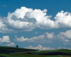 As
the sun rises higher in the sky, accelerating the rate of heating of the layer of air near
the ground, thermal puffs become more numerous, larger, and often show obvious vortex
ring, or partial ring shapes and the nocturnal inversion becomes increasingly unstable. At
some point, usually well past mid morning, the nocturnal inversion abruptly collapses, a
normal lapse rate condition is established, and large scale convective activity is
triggered. Fully developed plume thermals appear. The collapse of the nocturnal inversion,
the mixing caused by thermal puffs, vortex rings, and the generation of plume thermals,
finally beings the wind to ground level. The first picture on the right shows typical, fair weather
cumulus clouds, often described as Scattered Cumulus. The
clouds are the tops of plume thermals and are characterized by a puffy white, piled up
appearance, and flat bases. The flat bases mark the level of the dew point. When viewed at
close range, the the flat appearing base is usually seen to be concave as the warm
(relative to the surroundings), moist, air rushing upward pushes into the cloud. As cool,
descending, air replaces the rising warm air, the bases of plume thermals are eventually
undercut and the column of warm air lifts from the ground and rises into the base of the
cloud. Cut off from a continuous supply of warm, moist, air, the cloud loses its flat
bottom and quickly dissipates.
As
the sun rises higher in the sky, accelerating the rate of heating of the layer of air near
the ground, thermal puffs become more numerous, larger, and often show obvious vortex
ring, or partial ring shapes and the nocturnal inversion becomes increasingly unstable. At
some point, usually well past mid morning, the nocturnal inversion abruptly collapses, a
normal lapse rate condition is established, and large scale convective activity is
triggered. Fully developed plume thermals appear. The collapse of the nocturnal inversion,
the mixing caused by thermal puffs, vortex rings, and the generation of plume thermals,
finally beings the wind to ground level. The first picture on the right shows typical, fair weather
cumulus clouds, often described as Scattered Cumulus. The
clouds are the tops of plume thermals and are characterized by a puffy white, piled up
appearance, and flat bases. The flat bases mark the level of the dew point. When viewed at
close range, the the flat appearing base is usually seen to be concave as the warm
(relative to the surroundings), moist, air rushing upward pushes into the cloud. As cool,
descending, air replaces the rising warm air, the bases of plume thermals are eventually
undercut and the column of warm air lifts from the ground and rises into the base of the
cloud. Cut off from a continuous supply of warm, moist, air, the cloud loses its flat
bottom and quickly dissipates. 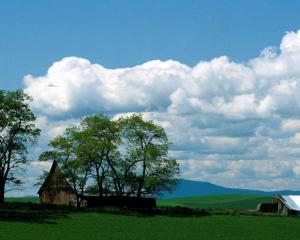 Most medium size cumulus clouds form, grow, and begin to
dissipate within about 20 minutes. However, as temperatures near the ground continue to
rise, thermal activity and the production of cumulus clouds often increase to the point
where the clouds spread and fuse to form a layer of stratocumulus cloud. The second
picture on the left either shows cumulus clouds beginning to fuse into a stratocumulus
layer. Since the layer is broken, the clouds are often called Broken
StratocumulusThe reduction in the amount of light reaching the ground reduces the
supply of warm air and slows convective activity. Gaps may then develop in the
stratocumulus cloud, allowing more sunlight reach the ground and initiating a new cycle of
heating, thermal development, and increase in cloud cover. Weather reports often use the
term 'sunny with cloudy periods' to describe this cycling of convective activity and cloud
cover. On the other hand, if conditions are such that a stratocumulus layer does not form,
then strong thermals will continue to be generated from about mid morning until late
afternoon. The second picture on the right shows this condition. Note that once a
butterfly is near cloudbase, it should be able to soar for hours as it would encounter
thermal after thermal as it makes its way across the sky. As the day progresses, the
mixing and heating of the air causes the dew level to rise, development of convective
activity usually proceeds in one of two directions, depending upon humidity, temperature,
lapse rate, rate of heating, topography, and other factors. Most days in most palces in
the temperate zones, thermals become larger and spaced further apart.
Most medium size cumulus clouds form, grow, and begin to
dissipate within about 20 minutes. However, as temperatures near the ground continue to
rise, thermal activity and the production of cumulus clouds often increase to the point
where the clouds spread and fuse to form a layer of stratocumulus cloud. The second
picture on the left either shows cumulus clouds beginning to fuse into a stratocumulus
layer. Since the layer is broken, the clouds are often called Broken
StratocumulusThe reduction in the amount of light reaching the ground reduces the
supply of warm air and slows convective activity. Gaps may then develop in the
stratocumulus cloud, allowing more sunlight reach the ground and initiating a new cycle of
heating, thermal development, and increase in cloud cover. Weather reports often use the
term 'sunny with cloudy periods' to describe this cycling of convective activity and cloud
cover. On the other hand, if conditions are such that a stratocumulus layer does not form,
then strong thermals will continue to be generated from about mid morning until late
afternoon. The second picture on the right shows this condition. Note that once a
butterfly is near cloudbase, it should be able to soar for hours as it would encounter
thermal after thermal as it makes its way across the sky. As the day progresses, the
mixing and heating of the air causes the dew level to rise, development of convective
activity usually proceeds in one of two directions, depending upon humidity, temperature,
lapse rate, rate of heating, topography, and other factors. Most days in most palces in
the temperate zones, thermals become larger and spaced further apart.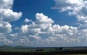 If
conditions are right, the thermals may become aligned in rows extending for tens of
kilometers, creating long bands of lift with parallel bands of sink on either side. These
highly organized convection systems are called cloud streets and, if
aligned in the appropriate direction, make it possible to soar in a straight line
underneath the clouds for tens of kilometers. However, if the pilot attempts to cross from
one cloud street to another, the strong sink is likely to force an out-landing. Of course
the butterflies can avoid this by switching from soaring to flapping flight. The other
pattern of convective development can be much more exciting. Cumulus clouds can continue
to build into towering
cumulonimbus, or thunderstorms. Unlike the rather explosive beginning of convection
earlier in the day, the decline in thermal activity at the end of the day is a more
gradual process.Towards the end of the day, as the setting sun heats the air near the
ground less and less, the distance between thermals continues to increase and the velocity
of the upward moving air slows and eventually quits. . Eventually, except perhaps for a
few thermal puffs, all convective activity stops and the clouds dissipate. This diurnal
cycle of thermal development is the reason that the sky is usually clear of clouds in the
morning hours and the hour or so before sunset. If is also the reason that migrating
monarch butterflies, having apparently spent hours aloft soaring, begin to descend from
the sky in the late afternoon or, on particularly good days, just prior to sunset.
If
conditions are right, the thermals may become aligned in rows extending for tens of
kilometers, creating long bands of lift with parallel bands of sink on either side. These
highly organized convection systems are called cloud streets and, if
aligned in the appropriate direction, make it possible to soar in a straight line
underneath the clouds for tens of kilometers. However, if the pilot attempts to cross from
one cloud street to another, the strong sink is likely to force an out-landing. Of course
the butterflies can avoid this by switching from soaring to flapping flight. The other
pattern of convective development can be much more exciting. Cumulus clouds can continue
to build into towering
cumulonimbus, or thunderstorms. Unlike the rather explosive beginning of convection
earlier in the day, the decline in thermal activity at the end of the day is a more
gradual process.Towards the end of the day, as the setting sun heats the air near the
ground less and less, the distance between thermals continues to increase and the velocity
of the upward moving air slows and eventually quits. . Eventually, except perhaps for a
few thermal puffs, all convective activity stops and the clouds dissipate. This diurnal
cycle of thermal development is the reason that the sky is usually clear of clouds in the
morning hours and the hour or so before sunset. If is also the reason that migrating
monarch butterflies, having apparently spent hours aloft soaring, begin to descend from
the sky in the late afternoon or, on particularly good days, just prior to sunset.
As you watch the sky watching for migrating butterflies, take time to study the different
types of clouds. Note thermal puffs (vortex thermals), cumulus clouds (plume thermals),
stratocumulus, and fractocumulus. If the sky was clear in the morning, but clouded over
with stratocumulus by about noon, check to see if the butterflies are still soaring in the
weaker lift maintaining the cloud layer by transporting moist air aloft. Periods of
overcast skies can provide particularly good viewing conditions for watching soaring
butterflies and birds because the light grey background is easier on the eyes than bright
whites of clouds or the glare of a cloudless sky. Try to guess whether a particular bit of
wispy cloud is just beginning to build into a cumulus cloud, or is the last evaporating
remnants of a dead thermal. Whether or not you guessed right will be soon be apparent.
Also consider whether there appears to be a sufficient density of flat bottomed clouds
(indicating active convection) to provide the butterflies with an abundant sources of lift
to soar cross country. With a little practice, you will find that you've become reasonably
good at reading the sky and are able to anticipate the breakup of the nocturnal inversion,
appreciate the diurnal thermal cycle, recognize cloud streets, and have a good idea where
the lift will be found when thermals are working. When you begin to plan a route across
the sky, from one source of lift to another, you're already thinking like a glider pilot.
It's probably only a matter of time before you start taking lessons. Or perhaps not.